Tropical Storm Helene to impact Middle Georgia starting Wednesday evening
Tropical Storm Helen is projected to become categorized as a hurricane before sunset Wednesday. Macon will experience its effects that evening with winds and rain.
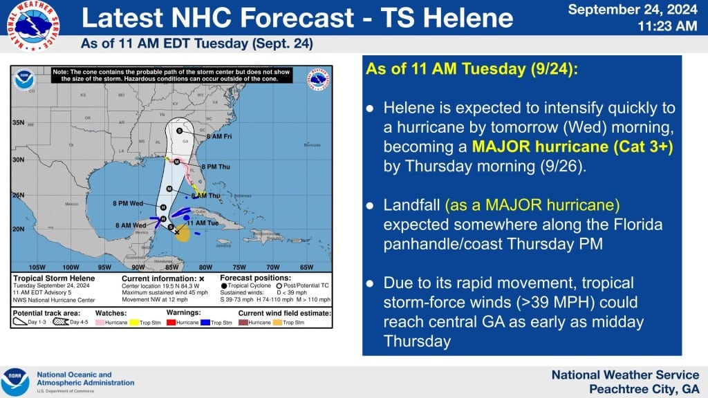
Tropical Storm Helene, projected to make landfall later this week as a hurricane, should bring high winds and heavy rainfall to Middle Georgia beginning late Wednesday evening.
Helene should build enough wind speed to be categorized as a hurricane around 8 a.m. Wednesday before it hits the Big Bend area of Florida around sunset that same day, according to National Weather Service meteorologist Vaughn Smith.
Folks in Macon will begin to feel Helene’s effects before it even makes landfall, with wind and rain hitting late Wednesday evening. By daybreak Thursday, there will be 10-to-20 mile-an-hour winds and some rain in Macon.
Middle Georgia will face Helene’s strongest winds — 30-to-40 miles per hour with potential gusts of up to 50 — Thursday night through early Friday morning. The statewide average rainfall is expected to be 3-5 inches Wednesday through Friday.
“You’ll definitely have some trees down, you’ll have some power outages, you’ll possibly have some flooding,” Smith told The Melody.
Helene is currently on track to travel just west of Macon before sunrise Friday before heading further north. Throughout the day Friday, skies will clear and winds will die off.
Residents are advised to stay updated on the weather forecast, be prepared for long power outages by charging batteries and devices ahead of time, buy 3-4 days worth of canned food and water and have a first aid kit prepared. To stay safe during flash flooding, move to higher areas.
Before you go...
Thanks for reading The Macon Melody. We hope this article added to your day.
We are a nonprofit, local newsroom that connects you to the whole story of Macon-Bibb County. We live, work and play here. Our reporting illuminates and celebrates the people and events that make Middle Georgia unique.
If you appreciate what we do, please join the readers like you who help make our solution-focused journalism possible. Thank you
Author

Related Articles
Macon copper thieves pocket little but leave businesses with steep bills
Copper prices are high and thieves are stripping air conditioning units from businesses and homes across the country.
Macon-Bibb’s 2027 budget proposal anticipates no tax rate increase, boosts public safety spending
Mayor Lester Miller wants more money for public safety in his proposed 2027 fiscal year budget.

Local documentary on World War II veterans to air in Macon
Director Trent Jones tells the story of veterans who served on a “Flying Fortress” during the war.