New Georgia map tool offers local climate change insight
Drawdown Georgia created a tool that shows the potential impacts of climate change across the state.
Local leaders across Georgia can now see a more detailed picture of what impacts to expect from climate change with a new map tool released by Drawdown Georgia.
The group, which aims to reduce the state’s greenhouse gas emissions, unveiled the maps at the recent Super South Summit in Atlanta.
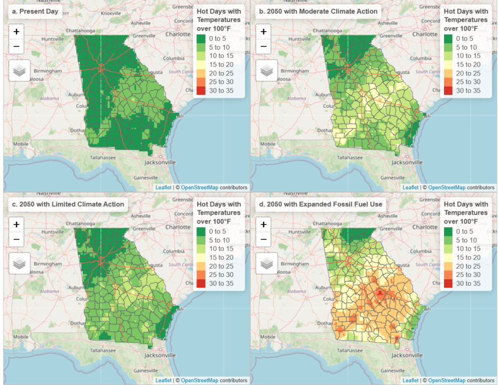
Scientists warn that Georgia can expect hotter, longer summers, more extreme weather, more rainfall overall and also longer droughts. But those impacts will vary across the state.
Now, researchers have found ways to scale down the big picture data so they can project not just how climate change is affecting Georgia or the Southeast broadly, but how it’s changing conditions in specific locations.
“Historically, [climate models are] locked into these huge global data sets,” said Georgia Tech professor Bill Drummond, who developed the maps and studies local and regional planning. “But we’re getting more and more tools to bring them out and bring them down to the local level, so that we can start to understand what it means at the county level or the city level.”
That could be key for local planning, which typically relies on past data to predict future conditions. But that approach assumes that it will rain about as much in a given location as it has in the past, or that temperatures will fall into the same general range — but because of climate change, Drummond said, those assumptions no longer hold up.
“We have to rethink the way that we have traditionally done planning for infrastructure to take into account the fact that the future will not be like the past,” he said.
More detailed forecasts of future rainfall can help local governments plan to build stormwater management systems that can better handle extreme storms brought on by climate change or help ensure hospitals aren’t built in places that will be cut off by flooding.
“In the United States, a lot of our planning is done at the local level,” Drummond said, pointing to decisions like land use and zoning. “And so a lot of adaptation planning is done at the local level.”
The maps compare current conditions with projections under three different climate change scenarios, with impacts varying based on whether and how much greenhouse gas emissions are reduced in the future, so local leaders can see and plan for different potential risks.
This coverage is made possible through a partnership between WABE and Grist, a nonprofit environmental media organization.
Before you go...
Thanks for reading The Macon Melody. We hope this article added to your day.
We are a nonprofit, local newsroom that connects you to the whole story of Macon-Bibb County. We live, work and play here. Our reporting illuminates and celebrates the people and events that make Middle Georgia unique.
If you appreciate what we do, please join the readers like you who help make our solution-focused journalism possible. Thank you
Related Articles
Own property in Georgia? Here’s how to read your 2026 tax assessment
Georgia’s annual tax assessment forms look different this year. Here’s how to read them.

Map redraw could cost Black voters in Bibb, legislators warn
The Georgia General Assembly meets this week to consider redrawing district lines and Bibb County’s delegation is concerned changes will disenfranchise Black voters.
Downtown Macon renovation projects in limbo after Kemp vetoes historic tax credit expansion
Legislation passed by the General Assembly would have increased the amount of historic rehabilitation tax credits made available to Georgia developers.